Recently a large expanse of sediment has been uncovered near Allonby, so....I'll let Tom explain ..thanks Tom...
 |
| The exposure with Allonby (Crookhurst) Beck, looking towards Criffel. |
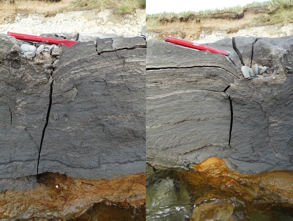
The recent erosion has exposed several facies. A facies is a deposit with a distinct character- expressed by its formation, composition and/or fossil content. In this case there are three main facies: the first one is a unfossiliferous pale grey clay, the second is a dark grey-brown sandy clay which is rich in organics and highly fossiliferous, and the third is an orange-red cobble-pebble conglomerate.
 |
A section showing the three facies- pale grey clay, dark sandy clay with organics and cobble-pebble conglomerate (top to bottom). The sequence is topped by wind-blown sand.
|
These facies can be repeated with the general sequence being:
- Wind-blown sand
- Facies I: darker, more humus rich clay
- Facies I: pale grey clay
- Facies III: red-orange cobble-pebble sediment with coarsening upwards sequences.
- Facies II: dark grey-brown clay, rich in organic matter.
- Facies II: dark grey-brown clay with pebble clasts
- Facies III: red-orange cobble-pebble sediment
Below I'll go through each bit of the sequence with a description.
Firstly on top of these sediments is the cover of wind-blown sand and pebbles. This can show cross-lamination, as seen below. This wind-blown sand is modern and regularly moves about on the beach.
 |
Wind blown sand with cross-lamination.
|
Beneath the sand there is a thin layer of peat, around 15cm, which sits upon around 130cm of pale grey clay. When dry, this clay is incredibly blocky, falling down the exposure and obscuring the sequence beneath. It is regularly exposed at the back of the beach.
The interface between the pale clay and the unit below is poorly exposed. Generally there is a thin (around 15cm) layer of cobbles and pebbles concreted together with an orange-red colour. This is usually accompanied by sand either side of the unit. In some areas this unit cannot be found it and forms lenses, replaced by sand.
Also found in this unit (usually seen from the top interface), are long cylindrical iron concretions, that form concentric layers around a small tube (below). I've seen these in other clays and think they could be concretions around roots, given their vertical orientation and size, though I've failed to find any information regarding them.
Beneath this unit is the unit with the greatest exposure- the dark grey clay which contains organic matter (facies II). This is exposed as a large flat expanse, with polygonal cracking on the surface, where the clay has dried out and cracked. Where the beck cuts through this the cross section can be seen, and distinct horizontal lamination can be seen, with clay and sand layers. At the base of the unit orange staining can be seen as 'bleed' through from the orange-red cobble-pebble unit beneath it.
If you look ontop of the clay, all sorts of organic matter can be seen. Firstly there are leaves, roots and mosses, which are all very degraded, but recognisable.
There are also some large clasts of 'bog wood'- interestingly many of these are well rounded (I'll get onto this later). As well as wood there is bark- some of which is identifiable, such as the birch bark, below on the right-hand side.
There are also
Planorbis planorbis gastropod shells, the common name of this snail is the margined ramshorn and hazelnut shells (below).
Beneath this unit there a thick unit of facies III with well rounded cobbles and pebbles. These include
Below is my interpretation of these sediments, based upon some quick research (by no means all-encompassing). Luckily there is a Report RR/11/04, The Quaternary Geology
of the Solway, by the Geology and Landscape (Scotland) Programme, gives a good overview.
The sediments in the exposure belong to the British Coastal Deposits Group, which includes raised beach and marine deposits. There are two sets of these raised marine deposits found in the area, one being formed in the late-glacial period (Late Devensian) at the same time as the meltwater channels on Aughertree were being formed by the receding glaciers
- see here-, and the second was formed in the mid Holocene (Flandrian)- it is likely that it is this set that these sediments belong to. These younger deposits are divided into shoreface and beach deposits (shingle and sand) and quiet- water sedimentary facies formed in tidal-flat, brackish lagoon and estuarine environments (fine-grained silt and sand). This description of the sediments from the Flandrian perfectly fits the sediments (and facies) at Allonby.
Equivalent raised marine deposits are best developed on the north shore of the Solway, around the estuary of the River Nith.
There are interesting features in the sediments at Allonby. For example the pieces of bog wood that form clasts are all well rounded. If the surrounding sediment was formed in a tidal-flat/brackish lagoon/estuarine environment it makes sense that the wooded would be well rounded due to the influence of water- similar to today's driftwood. Also the fauna and flora is of interest. Hazel nuts, mosses and birch bark were likely transported to the locality in the water and the Planorbis planorbis (Margined ramshorn) snails are no longer found in the immediate area. The snail's habitats are ponds, ditches and very slow flowing water on silty/clayey substrates, and while they are now not found in the Allonby area, they can be found at Grune Point near Skimburness. Perhaps the area of greatest interest is the importance of like sediments in the study of sea level change.
Hopefully, this has provided an overview of the recently uncovered sediments at Allonby as well as a likely interpretation. For further reading see:
The Quaternary Geology of the Solway: http://nora.nerc.ac.uk/id/eprint/15834/1/RR11004.pdf
Holocene Relative Sea-Level
Changes along the Northwest
Cumbrian Coastline PHd thesis: http://etheses.whiterose.ac.uk/24100/1/MohdHanan_DSM_PhD_Final.pdf